To restore the heritage of year-round, free-flowing rivers in the Santa Cruz and San Pedro Binational Watersheds
We invite you to join us in forging a new path for Arizona’s water future.
Goals
2025
2030
2040
2050
2060
2070
Not only do we have a dream, we also have a clear plan on how to achieve it
Our team has developed a 50-year strategic plan to achieve our 50-year vision to restore Tucson’s heritage of flowing rivers. Our goals cover our four focuses of the River Run Network: community engagement, watershed planning, restoration, and policy.
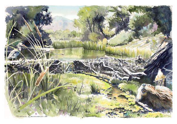
Las Ciénegas National Conservation Area
The American Beaver once again is a keystone species in the Santa Cruz Watershed with a robust population thriving in Las Ciénegas National Conservation Area. Ciénega Creek has regained its historic flow extent with over 13 miles of perennial flow in the conservation area, thanks to the return of the beavers and a collaborative community effort to protect the groundwater aquifer. The beaver’s small, natural dams slow the flow and pond water across a broader floodplain. The more frequent, deeper pools of water supports a larger population of native fish and is a hotspot for Gila Chub, Gila topminnow, longfin dace as well as yellow-billed cuckoo, Southwestern willow flycatcher, Chiricahua leopard frog and the Mexican garter snake. The spreading of water across the landscape widens the floodplain to support one of the largest riparian forests in Southern Arizona, as well as allowing more water to seep into the aquifer. The aquifer is a big sponge, storing water for later to create water security for greater Tucson, and providing 20% of the groundwater inflow to the Tucson Basin.
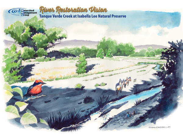
Tanque Verde Creek at Isabella Lee Natural Preserve
Tanque Verde Creek at Isabella Lee has sections of year-round and seasonal meandering flow fed by groundwater and surface flow from the Rincon Mountains as well as the Santa Catalina Mountains through Agua Caliente Creek. Seasonal flow supports large populations of the lowland leopard frog and Mexican gartersnakes. The large cottonwood-willow riparian forests support rare birds such as the blackhawk, cactus-ferruginous pygmy owls and yellow-billed cuckoo. The creek has an extensive floodplain, a natural sponge to absorb large flood events and increase recharge, supporting a vast mesquite-velvet ash-hackberry bosque (forest). The area is treasured by the communities in the Tanque Verde Valley as a destination for bird watching, hiking, horseback riding and nature appreciation.
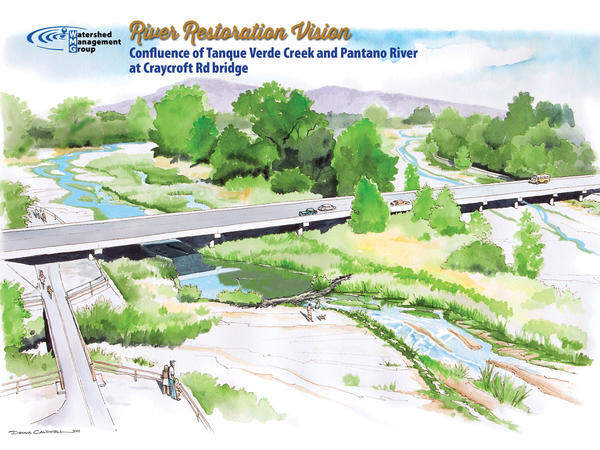
Confluence of Tanque Verde Creek and Pantano River
The lower Tanque Verde Creek has year-round and seasonal, meandering flow that feeds a ciénega (wetland) with tall stands of riparian grasses, alive with the sounds of native frog and toads. Regular flow invites native fish populations of the Gila topminnow and Gila chub to return as well as the illustrious American beaver. The reintroduced beavers enhance the creek through low mud-packed leaf dams that help slow the flow of water and provide for rich and diverse riparian habitat. Seasonal flows of the Pantano River help connect populations of native fish from Ciénega Creek to Tanque Verde Creek. The extensive floodplain is a natural sponge to absorb large flood events and increase recharge supporting an extensive mesquite bosque (forest). The mesquites, interspersed with cottonwoods and ash trees, create a shady oasis home to an abundance of wildlife and endless recreation opportunities for families.
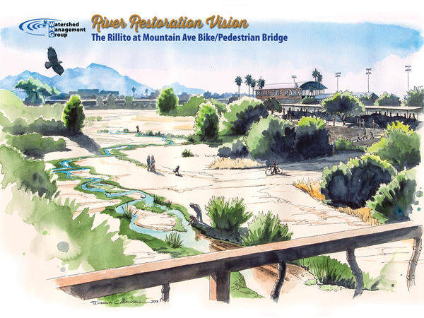
The Rillito
The Rillito is Tucson’s darling, capturing the community’s heart and imagination by bringing its wet and wild wonder into the urban core. The river is alive with seasonal flows, supported by healthy groundwater levels, which are fed by stormwater infiltrated through green infrastructure throughout the surrounding neighborhoods. Parking lots and impervious areas are reduced and replaced with rain garden parks and native habitat. The Rillito’s lush floodplain supports important riparian species with great wildlife viewing and recreation opportunities, tying into cultural amenities like the racetrack, restaurants, and the bike loop. People come to view the growing bat populations, hear breeding toads in the monsoons, along with enjoying fabulous bird watching all winter long.
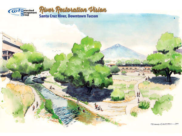
Santa Cruz River, Downtown Tucson
The Santa Cruz River flows year-round at the base of Sentinel Peak – supported by a healthy groundwater aquifer. The flowing river is a cultural and ecological gem of our desert community that is essential to our city’s economy and livability. A river walk meanders near the Santa Cruz under a mesquite bosque for people to enjoy the riverside up close, where they can picnic and recreate. Restaurants and parks dot the outskirts of the floodplain and are popular places for fiestas and festivals –once again becoming the center of cultural affairs. The riparian forest is a haven for dozens of bird species, and native wildlife is abundant.
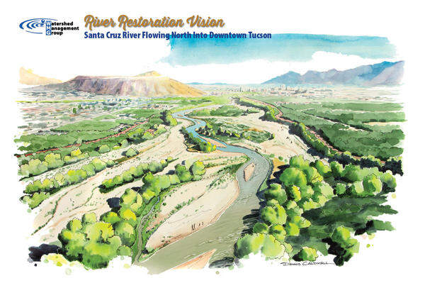
Santa Cruz River, South of Downtown
The Santa Cruz River’s shallow, meandering course has sections of year-round and seasonal flow from Martinez Hill (near San Xavier Road) to downtown Tucson. This flow is groundwater supported, running subsurface from the restored Great Mesquite Forest on the San Xavier District lands of the Tohono O’odham Nation. The forest, once the largest mesquite bosque in the United States, has recovered much of its historic territory and supports over 80 summer bird species, thanks to the rich habitat provided by mesquite trees reaching up to 60 feet tall. Native fish thrive in the year-round flows, with restored populations of Longfin dace, Gila chub, Sonora sucker, Desert sucker, and the Gila topminnow. Small, family farms, found throughout the floodplain, provide fresh food to local markets while preserving open space with practices that protect precious groundwater and top-soil. The river is a cherished natural area for Tucson-area residents to walk, bike, and enjoy family gatherings along the river bank.
Become Part of the Vision
Everyone has a part to play in restoring Tucson's heritage of flowing rivers