
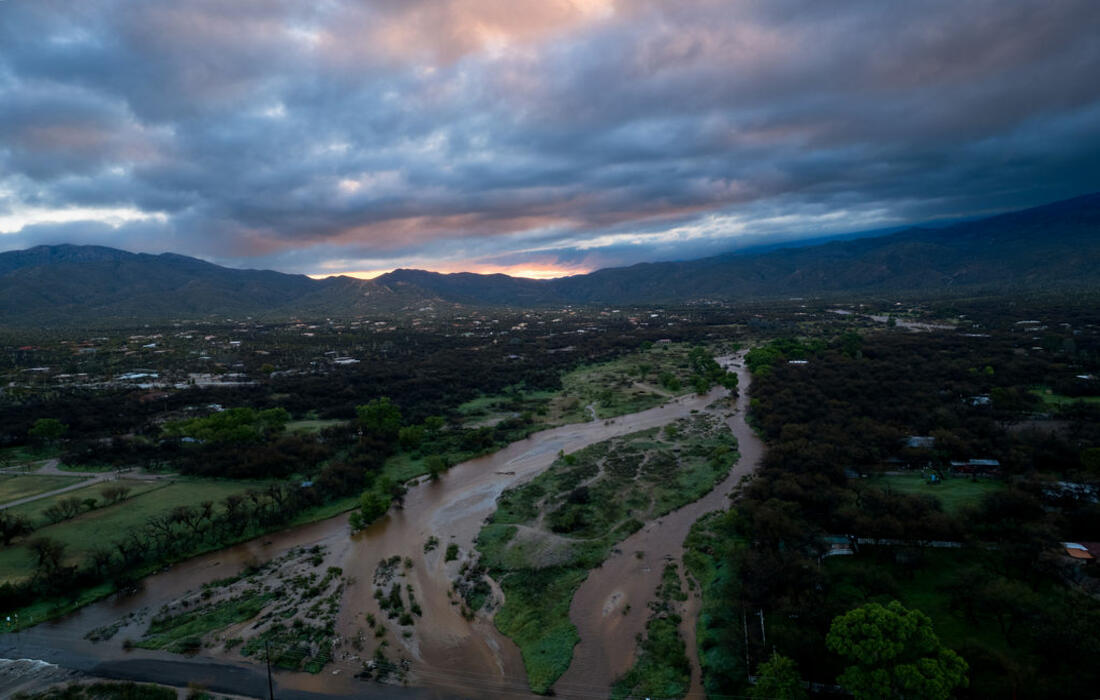
Record breaking rain and flow in spring months, more flow days overall than 2022
2023 Water Year Flow365 Annual Report
We are pleased to share our 2023 Flow365 Annual Report made possible thanks to 92 Flow365 community scientists who captured data for 46 sites across the Tucson basin. This community science operation is led by volunteers trained through WMG's River Run Network— a group of people working together to restore Tucson's heritage of flowing creeks and rivers.
This year’s data indicates that we had more days of flow throughout most of the city compared to 2022 due to more than average rainfall during our winter rainy season. However, some of the sites highlighted below had decreased flow through our monsoon season, due to less than average monsoon rain. For example, the site we call the Wentworth Bosque along the Tanque Verde Creek was reported to have continuous flow from October 2022 to mid-July 2023 and did not have flow for the rest of the water year.
In the 2023 water year, Tucson received 10.07” of rain (NOAA) compared to our 11.92” average; receiving more of that rain in the winter/spring of 2023. Tucson experienced the hottest monsoon season on record, with an average of 89.8° and a fairly dry monsoon season with only 4.73” of rainfall compared to an average monsoon season of 5.69” rainfall. With the data we’ve compiled from the 2023 water year, we saw record days of flow along parts of the Rillito and Agua Caliente in the springtime, due to abundant winter rainfall and snowpack.
Flow365 data is giving us a much better understanding of the flow extents and number of flow days across creeks and rivers in the Tucson Basin, thanks to weekly and even daily monitoring, including recording low flows not caught by flow gauges. Over time, this data also helps us determine the impact of collective conservation actions on creek flow as we strive towards our long-term goal of restoring Tucson’s heritage of flowing creeks and rivers.
The data is used by the Santa Cruz Watershed Collaborative (SCWC) as part of their watershed health metrics as well as shared with ADEQ and Pima County. The Flow365 data set can inform local drought triggers and drought response as well as informing climate resilience strategies.
The rest of the report includes highlights from the data our Flow365 Monitors collected for the 2023 water year from the Santa Cruz River along Ina Rd and Twin Peaks Rd as well as Agua Caliente and Soldier Trail, Pantano Creek and Colossal Cave Rd, the Canada Del Oro River and Magee Rd and Cienega Creek and Marsh Station Rd.
1Santa Cruz Watershed Collaborative: People working together to ensure a natural heritage of healthy urban watersheds with flowing rivers and creeks. santacruzwatershedcollaborative.net
22100 One Water Plan: The One Water approach treats all water resources as equally important, including surface water, groundwater, recycled water, and rain and stormwater harvesting. https://tucsononewater.com/
3Tucson’s Climate Resilience Plan: The Climate Action Plan—known as Tucson Resilient Together—will provide a strategic pathway to reduce the City’s emissions to net zero by 2030, explain the anticipated impacts of climate change across the City, identify the communities that will be most vulnerable to those impacts, and provide strategies that will assure that Tucson can adapt and be resilient to the impacts of climate change – now and in the future. https://climateaction.tucsonaz.gov/
2023 Water Year Data: October 1st, 2022 – September 30th, 2023
Table of Contents:
1. Sabino Creek
|
5. Cañada del Oro River
|
Sabino Creek
Our Monitors observe several sites at the base of the Catalina Mountains. On the east side of Tucson, they capture data from Bear Creek and Lower Sabino Creek. These creeks start in the mountains, with rain and snowmelt feeding surface flows. When the creeks move into the valley, there are some places where shallow groundwater aquifers also support surface flow in addition to rain and snowmelt, however, we are concerned about reduction in flow at the particular site mentioned in this report.
Flow365 Site: Sabino Creek at Wes Miller Park
Flow365 Monitors: Wendy Beall
2023 Water Year Flow: 365 Days
2016 - 2022 Water Years Flow: 365 Days


Lower Sabino Creek is privately owned by a variety of mostly residential landowners. We have captured data since the start of our program with permissions from the surrounding private landowners and the homeowners association who use and preserve this area. The restored perennial flow that we observed from 2016 to 2022 is likely the result of a reduction in groundwater pumping which was reduced at several major pumping sites. However, Wendy Beall, the Flow365 Monitor in the area, started to observe lower level flows mid-August 2023. This is highly unusual for this site as we have not seen this since the Flow365 Monitoring Program began in 2016.
Why is there recent drying up after seven years of year-round flow? This shallow groundwater area, where water is within 50 feet or closer to the surface, is heavily affected by many factors including rainfall, infiltration, and groundwater pumping! This monsoon had less than average rain, as in previous years, and this is the first time we have seen the flow slow to just ponding water. The Flow365 Monitoring Program is interested to know more about what is happening upstream of this area. If groundwater pumping has increased, it could explain why this perennial stream is drying up.
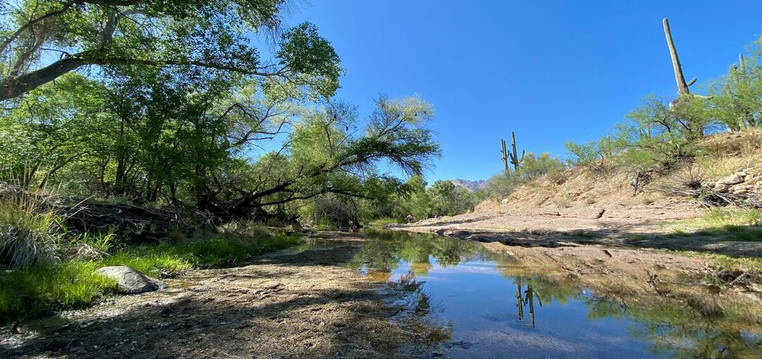
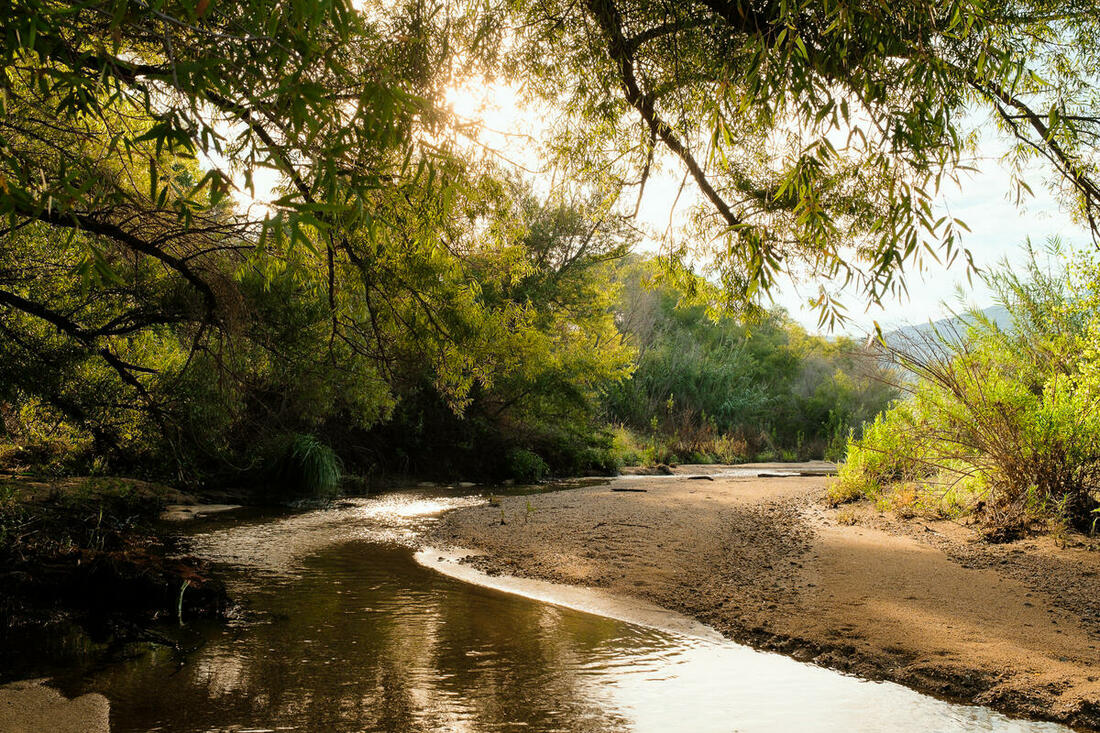
Agua Caliente Creek
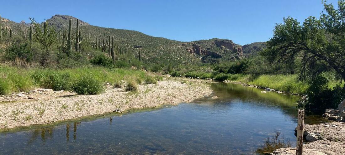
North of Tanque Verde Creek, at the foot of the Catalina Mountains, Agua Caliente Creek runs just west of Agua Caliente Park and eventually meets up with Tanque Verde Creek. Our monitors have revealed that flow in this area is dependent on rain and snowmelt. Though it does not flow year round, data shows short intermittent flows throughout our winter season due to snowmelt. The creek is able to meander freely in much of its floodplain and has more natural flow, unlike some of the channelized rivers in the urban core.
Flow365 Site: Agua Caliente Creek at Milagrosa Lane
2023 Water Year Flow: 100 Days
Most consecutive flow (2023): 100 Days
2022 Water Year Flow: 82 Days
Most consecutive flow (2022): 46 Days
Flow365 Monitors: Bethany DeRango, Andrea Martin


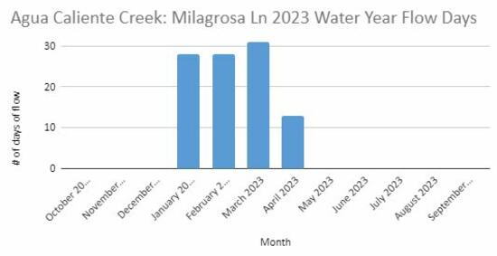
The Flow365 Monitors observed 100 days of consecutive flow at this site in the 2023 Water Year. Flowing from January 4th, 2023 to April 11th, 2023, this is the most flow we have ever recorded at this site. As our Monitors have been gathering consistent data for this site, we have seen an interesting pattern emerge. After rain events, the flow will stay for days after the rain has stopped. We hope to learn more over time from the data our two monitors collect, and continue to see this area flourish and flow even after the rains have stopped!
Flow365 Site: Agua Caliente Creek at Soldier Trail
2023 Water Year Flow: 97 Days
Most consecutive flow (2023): 92 Days
Flow365 Monitors: Dan Roskey, Darrel Emerson


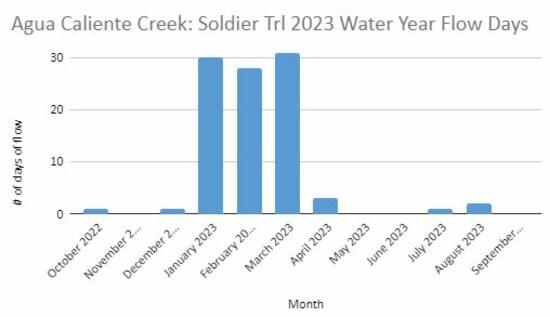
Did you know that some of our creeks and rivers flow across our streets? Agua Caliente is one of these, and this particular site is the second-farthest upstream site we have along this creek. The 2023 Water Year was the first year we had enough data on this site to understand a bit about what is happening, and in comparing our Milagrosa Lane site to this one, we can see that there is only eight days of difference in flow, indicating that much of the rainfall and snowmelt is reaching farther downstream than originally thought. This is an exciting observation because it could mean groundwater recharge and more flow to come in the Agua Caliente!
Tanque Verde Creek
Historically, stretches of the Tanque Verde Creek were often flowing, either seasonally or year-round. But since the mid-1900s, this creek has been drying up with the loss of seasonal and year-round flows due to depleted groundwater levels. This area has one of the few remaining riparian forests with floodplain connection in the Tucson basin, including Fremont cottonwood, Goodings willow, Mexican Elderberry, and Velvet mesquite, as well as many other riparian plants native to the Sonoran Desert. Unfortunately, it has more recently become home to an invasive species called Arundo donax, a giant cane reed. This highly flammable weed crowds out native plants, and sucks up 3-4 times the amount of water as native plants, diminishing flow. Through WMG’s River Run Network, we are working to remove this species along the Tanque Verde Creek and eradicate it in the next five years. To date, we have removed invasive Arundo from 55 acres of the creek. Learn more about our Arundo removal efforts and how to get involved here.
Flow365 Site: Tanque Verde Creek: Wentworth Bosque
Flow365 Monitors: Richard Pello, Lee Pello, Heidi Shewel, Jim Washburne
2023 Water Year Flow: 239 Days
2022 Water Year Flow Days: 276 Days
2021 Water Year Flow: 70 Days
Most consecutive flow days: 288 days, July 23, 2021 – May 6th, 2022


 WMG has observed seasonal flows in this area since 2019. Between the 2021 and 2022 Water Years, our Monitors recorded 288 days of consecutive flow (July 23, 2021 - May 6th 2022), by far the most flow we’ve observed in this area. The area flowed from January 4th, 2023 to July 15th, 2023, but had little to no flow for the rest of the 2023 water year.
This area has substantial opportunity to continue to see flow days and flow amounts increase over time, even with potentially drier years due to climate change. More local groundwater recharge efforts, reduced groundwater pumping, and the removal of Arundo donax can continue to enhance flow in this area.
This middle stretch of the Tanque Verde Creek tells an amazing story of resilience and the potential for humans’ impact on restoring flow and shallow groundwater areas. This is an area that likely had perennial flow historically, but it dried up with overpumping. The nearby golf course that was pumping groundwater switched to reclaimed water in 2005, and since then the aquifer has been steadily recovering with seasonal flows emerging. This groundwater recovery has occurred in a time of multi-decadal drought, with many years of less than average rainfall.
Rillito River
Because of The Loop path and many parks along its banks, the Rillito River is popular with the Tucson community as a corridor to walk, run, bike, and picnic. The Rillito River is fed by the Tanque Verde and Pantano Creeks, flowing from east to west, eventually connecting with the Santa Cruz River. The Rillito River is also known for a large bat population, the Mexican free-tailed bats, that lives in large colonies under several bridges that cross the river.
Flow365 Site: Rillito River at Craycroft Rd
Flow365 Monitors: Catlow Shipek, Kerry Murphy, Susan Swartz, Oliver Wilson, Ken Lubinski
2023 Water Year Flow: 113 Days
Most Consecutive Flow (2023): 107 Days
2022 Water Year Flow: 62 Days
Most Consecutive Flow (2022): 27 Days
2021 Water Year Flow: 85 Days
Most Consecutive Flow (2021): 56 Days


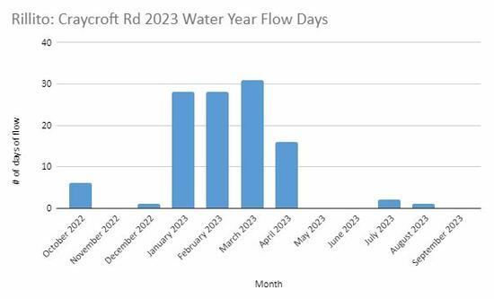 Monitors recorded an impressive 107 consecutive days of flow at this site, from January 4th, 2023 to April 15th, 2023, significantly more flow days than anything we’ve recorded since monitoring began in 2016. Slower, gentle flows, that most often take place in the winter, are when most of the groundwater recharge takes place. So, with over 3 months of gentle, winter flows at this site, there was substantial groundwater recharge.
This site is the confluence of the Tanque Verde Creek and Pantano Creek and is considered a shallow groundwater area, with water within 50 feet of the surface. The shallow groundwater still supports some cottonwood trees from a historically much larger cottonwood forest, as well as a Mexican elderberry grove upstream of the confluence. Historically, this area had year-round flow through a large ciénega (marsh) with a large mesquite bosque (forest), supporting indigenous populations.
The presence of cottonwood trees, which need water within 30 feet of the surface to survive, indicates perched aquifers and/or the presence of springs. A rheocrene spring has been documented just upstream of the confluence in the Tanque Verde Creek.
Cañada del Oro River
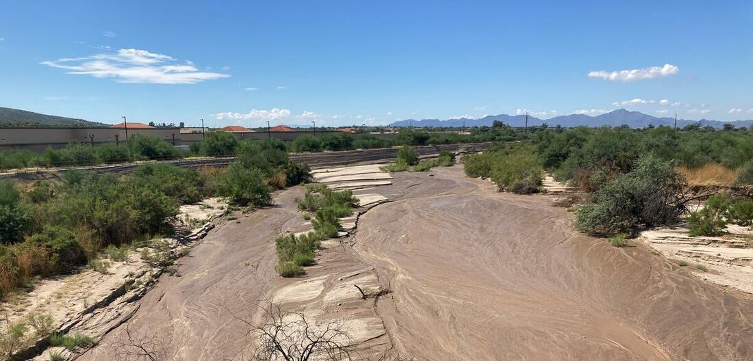
The Cañada del Oro River originates in a remote portion of the Catalina Mountains north of Tucson. Fed by rainfall and melted snow, it flows north toward the town of Oracle and then turns south toward Oro Valley where it is usually seen as a dry riverbed. The Cañada del Oro ultimately feeds into the Santa Cruz River just northwest of the city.
Historically, the Cañada del Oro River was largely intermittent and ephemeral; this means that even without groundwater pumping and floodplain channelization, it only had above-ground flow during rainy seasons. However, there are reports that some areas were plentiful with water close to the surface, like at the Steam Pump Ranch in Oro Valley. This means that even though there was no surface flow, much of the Cañada del Oro River could have been considered a shallow groundwater area.
Flow365 Site: Cañada Del Oro at 1st Ave
Flow365 Monitors: Angela Greynolds, Kelly Windsor, Johanna Stansfield, Julie Ray, Michael Smejkal, Thomas Fresneau
2023 Water Year Flows: 7 Days
2022 Water Year Flows: 16 Days
2021 Water Year Flows: 12 Days


This area along the Cañada del Oro is one of the most consistently monitored, with 6 Monitors visiting almost every week. We consider this area ephemeral, only flowing when there is rainfall. Even with rain, it does not flow often. Historically, this area would have been considered intermittent, flowing for a short time after the rains subsided but not flowing year round.
Flow365 Site: Cañada Del Oro at Magee Rd
Flow365 Monitors: Eva Miller, Christie Renick, Cass Fox
2023 Water Year Flow: 0 Days


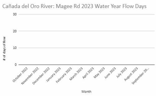
This portion of the Cañada Del Oro River is also considered ephemeral. Unfortunately, due to less than average rainfall in our 2023 monsoon season, there has been no flow recorded for this site in the 2023 water year. This area would be prone mostly to fast flowing water, known as a flash flood. This will most likely occur with input from storm drains as well as upstream flow.
Pantano Creek
 Pantano Creek originates at the confluence of Ciénega Creek and Agua Verde Creek, southeast of Tucson near Vail. Flow is primarily contributed from Ciénega Creek and secondarily through Rincon Creek, which originates east of Tucson near Rincon Peak. Pantano Creek flows north to join with Tanque Verde Creek at Craycroft Rd, becoming the Rillito River. Although it is fed from two creeks with seasonal and perennial flow stretches, this creek rarely flows as the water typically sinks into the ground before it can flow over the surface into Tucson. Though there is not much flow observed from this creek and it is disconnected from its floodplain due to concrete bank stabilization, the creek has a beautiful meandering pattern when it does flow, emulating the natural course a desert river takes.
Flow365 Site: Pantano Creek at Colossal Cave Rd
Flow365 Monitors: Holli Strand
2023 Water Year Flows: 15 Days
Most consecutive flow days: 8 Days


This site is the farthest upstream along the Pantano Creek, which means it is closest to where the Pantano Creek forms from Ciénega Creek and Agua Verde Creek. This site sees flow ephemerally, meaning only in response to precipitation. Though this area doesn’t flow often, we did see some flow during the 2023 water year due to the Pantano Creek’s connection to the Rincon Mountains.
Ciénega Creek

This creek is perennial in many stretches, and reaches from the base of Mount Wrightson to eventually connect to Pantano Creek. The River Run Network spends quite a bit of time in Ciénega Creek. From restoration workshops in Empire Ranch where we are planting native plants and moving rocks to slow spread and sink flow into the ground, to fence line surveys in the National Conservation Area in the upper reaches to support the reintroduction of beavers, we are always in awe of Ciénega Creek.
Flow365 Site: Cienega Creek at Marsh Station Rd
Flow365 Monitors: Savannah Sanchez
2023 Water Year Flows: 365 Days


The Flow365 Monitor here began collecting data at the beginning of the 2023 water year. This is the first year in the Flow365 Monitoring program that we have been able to see what is happening in this area, and our volunteer observed perenial flows even with less than average monsoon rainfall this water year. Lauren Knight, our River Run Network Program Manager, was able to go out and visit this site. You can see the video she created here.
Santa Cruz River
The Santa Cruz River historically flowed year-round until early 1900s and was home to many species of native fishes, frogs, and other aquatic species. Over time, groundwater pumping caused water levels to decline, changing the flow to ephemeral in the 1940s. At present, stretches of the Santa Cruz River flow perennially in Tucson with the input of effluent or treated wastewater. Many of these projects were developed to recharge water in the aquifer to store for future use; however, having consistent flow in the river has also created a riparian habitat throughout different stretches that can support native fish and provide a necessary resource to other wildlife as well as an amenity that is attractive to surrounding neighborhoods, cyclists, and pedestrians on the Loop.
Flow365 Site: Santa Cruz River at Starr Pass Blvd
Flow365 Monitors: Hannah Tanquary
2023 Water Year Flow: 365 Days
2022 Water Year Flow: 323 Days
2021 Water Year Flow: 365 Days


 This stretch along the Santa Cruz River has been flowing perennially with the release of effluent flow from the Santa Cruz Heritage Project since 2019. With this release of water, the site has changed quite a bit. From a barren sandy river bed to a budding riparian area, the released water has allowed some riparian plants to return as well as supporting wildlife like fish, frogs, birds, and dragonflies.
Flow365 Site: Santa Cruz River at Ina Rd
Flow365 Monitors: Sue Murphy
2023 Water Year Flow: 365 Days
2022 Water Year Flow: 365 Days


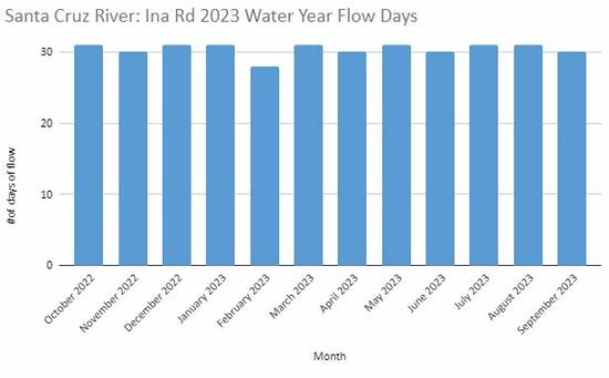 A bit farther north, or downstream, along the Santa Cruz River, a Flow365 Monitor has been collecting data along Ina Rd, a site that also has consistent effluent flow from the Tres Ríos Water Reclamation Facility. Water has been released into this area since the 1970’s, supporting plant and animal life like turtles, large fish, and the occasional crane in the area that were photographed by the Flow365 Monitor in this area.
The photos from this site also present an interesting phenomenon. The flow starts just south of the Ina Rd bridge, so the background in these photos is typically dry and barren of vegetation. Then, the water flows in from the east side bank just before the bridge and changes everything. Flows in the Heritage stretch and the Ina Rd stretch only connect when there is additional rainwater/stormwater flows during our rainy season. Flow connectivity, even if only seasonal, is a good way to connect populations of native fish as well as support riparian vegetation.
Flow365 Site: Santa Cruz River at Twin Peaks Rd
Flow365 Monitors: Nancy Grosvenor
2023 Water Year Flow: 365 Days
2022 Water Year Flow: 365 Days
2021 Water Year Flow: 365 Days


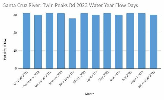 As we continue downstream, we reach Twin Peaks Rd where a single monitor has been consistently collecting data since 2021. The effluent flow released at Ina Rd reaches here and heads all the way north to Marana, flowing as far as Trico Rd. Monitor Nancy Grosvenor, often accompanied by her dog, enjoys going down to this site to collect data and explore the area. The portion of the channel is very narrow, but there is still room for fish to swim in the water and you can often see swallows nesting under the bridge as you walk to the water.
This site is visited often in our creek walk series “Santa Cruz River Flows”, where the River Run Network invites you to join one of our staff on a guided walk to explore recycled water flow areas along the Santa Cruz River.
Thank you for reading our Flow365 Annual Report, we look forward to gathering more data and presenting reports in the years to come.
References:
1. Sonoran Institute. “Living River Charting Santa Cruz River Conditions.” September 19,2022, https://sonoraninstitute.org/files/Living-River-Downtown-Tucson-to-Maran...