Less flow days than record-breaking 2021, however, seasonal and perennial flows persist
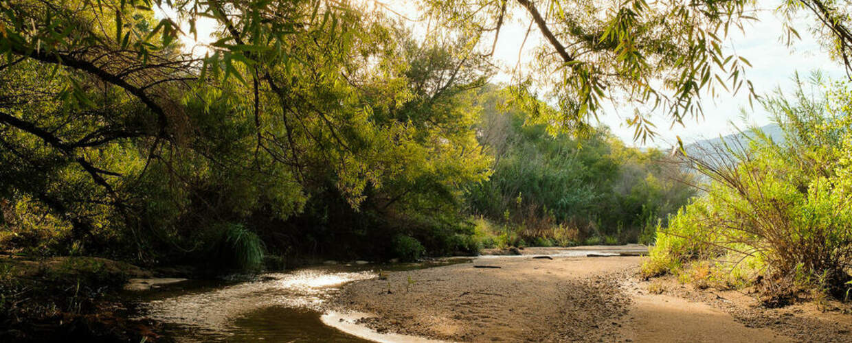
Summary of 2022 Water Year: October 1st, 2021 – September 30th, 2022
This year’s data tells us we had less days of flow throughout most of the city compared to 2021, due to less than average rainfall during both our monsoons and winter rainy season. However, some of the sites highlighted below had increased flow through our rainy seasons, and the city has added another effluent release site to the Santa Cruz river, upping flow days near South Tucson.
In the 2022 water year, Tucson received 7.41” (NOAA) compared to our 11.92” average; however, it followed a very wet 2021 monsoon season, with impacts on flow that persisted into the first half of the 2022 water year. With the data we’ve compiled so far, we can clearly see there are areas with year-round flow like Lower Sabino Creek, as well as areas with seasonal flows that are beginning to return, like Tanque Verde Creek.
All year long, our Flow365 community scientists were on the scene, capturing flow data for specific streams throughout the Tucson basin. This community science operation is led by volunteers from our River Run Network— a group of people working together to restore Tucson's heritage of flowing creeks and rivers.
While county agencies have flow gauges at some points across Tucson to be able to alert the public about flooding, the data our Flow365 volunteers have been collecting since 2016 fills a gap in data by recording gentler flows. This program helps capture how flow starts and stops at different times of year, and helps us understand the unique nature of our desert rivers and how they respond to changes in precipitation and groundwater levels.
Our Flow365 monitors collect flow data on a regular basis, at least once a month, but often weekly or even daily during periods of changing flow. Over time, this data also helps us determine the impact of collective conservation actions on creek flow, as we strive towards our long-term goal of restoring Tucson’s heritage of flowing creeks and rivers.
Because of our monitor’s consistent data collection, we are able to correlate the flows in our creeks and rivers with rain and snowfall, painting a more complete picture of flow in Tucson’s creeks and rivers. This big picture perspective will help us adapt to climate change, as well as a growing population that places ever higher demands on our regional and local water sources.
We’re pleased to share highlights from the data our Flow365 monitors collected for the 2022 water year, which started October 1, 2021 and ended September 30, 2022. Looking at the water year is a better way to analyze river flow than the calendar year, because it takes into account how the seasonal fluctuations of our winter precipitation and summer monsoons impact flow.
Santa Cruz River
Beginning north of Silverlake Road, this reach historically flowed year-round until 19411 and was home to many species of native fishes, frogs, and other aquatic species. Groundwater pumping caused water levels to decline, and the reach has been ephemeral since the 1940s. Year-round flows returned in June 2019, with the launch of the Santa Cruz River Heritage Project by Tucson Water. This project was developed primarily to recharge water in the aquifer to store for future use; however, having consistent flow in the river has also created a small riparian habitat that can support native fish as well as an amenity that is attractive to surrounding neighborhoods and cyclists and pedestrians on the Loop.
The Santa Cruz River is again home to two native fish species once common in this stretch before it dried: the Gila topminnow, released in October 2020, and the longfin dace, released in March 2022. Due to illegal introduction, non-native Western mosquito fish are also present in the river. So far, efforts to eliminate these invasive fish have been unsuccessful. To give native species a fighting chance, newly installed signage reminds people not to release pets, plants, or wildlife into the river.
Flow365 Site: Santa Cruz River at Starr Pass Blvd
Flow365 Monitors: Hannah Tanquary
2022 Water Year Flow: 323 days
Most Consecutive Flow Days: 235 days
2021 Water Year Flow: 365 days
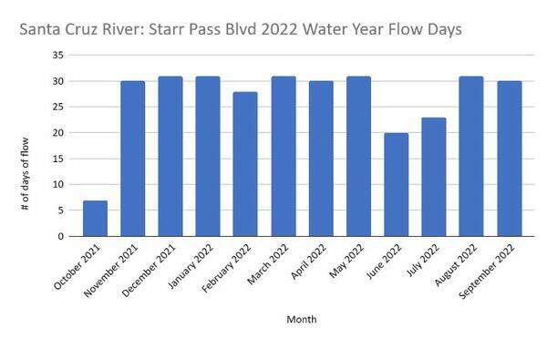
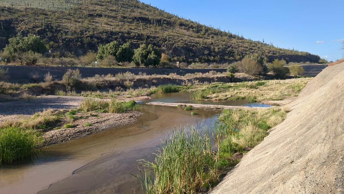
This stretch along the Santa Cruz River has been flowing perennially with the release of effluent flow from the Santa Cruz Heritage Project since 2019. With this release of water, the site has changed quite a bit. From a barren sandy river bed to a budding riparian area, the released water has allowed some riparian plants to return as well as supporting wildlife like fish, frogs, and dragonflies. Through the River Run Network, our 50-year vision is to see our creeks and rivers flowing again, and with this site, part of that vision is coming true! Our monitors here have captured incredible photos and data to share about the growth of this site and the effect it has on the downstream sites with this water as well. We are encouraged by the amount of flow days captured by our Flow365 Team, and though we are not sure why there were less flow days in 2022 than in 2021. We know water releases can be reduced or stopped due to maintenance needs or if groundwater levels are rising too quickly, and might get close to old landfills.
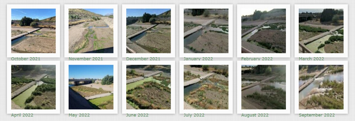
Monthly Photos at Santa Cruz River Star Pass Blvd:
Flow365 Site: Santa Cruz River at Silverlake Road
Flow365 Monitors: Alicia Weigh
2022 Water Year Flow: 169 days
Most Consecutive Flow Days: 169 days
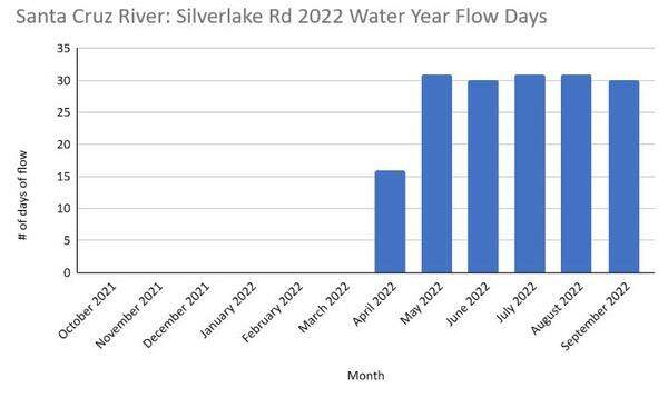
A bit farther upstream, our Flow365 monitors have been monitoring a new flow area, thanks to contributions of remediated groundwater that Tucson Water manages. This area started to flow in April with the release of TARP (Tucson Airport Remediation Project) remediated groundwater, flowing all the way from the Irvington Rd Outfall. The TARP remediation project began in the 1990’s due to contaminants in a section of our groundwater in Southern Tucson. The TARP Project has been remediating these contaminants (mainly trichloroethene, or TCE), however, an emerging contaminant, PFAS, was detected in June 2021 creating greater concern for the ability to treat and serve the water for potable consumption. In response, Tucson Water upgraded their remediation to include PFAS removal, and decided to release the treated water in the Santa Cruz River instead of through the potable water system.2
One year later (2022), this water is now being successfully treated to safe levels once again, and the choice was made to release the water into the Santa Cruz River as a temporary recycled water amenity, similar to the Santa Cruz Heritage Project. Our monitors are capturing data upstream of this outfall and downstream, at the Silverlake Rd site featured here. We are hopeful this project will have a positive impact on our desert wildlife and plants, and get more people interested in visiting and protecting the Santa Cruz River.
Monthly Photos at Santa Cruz River Silverlake Rd:
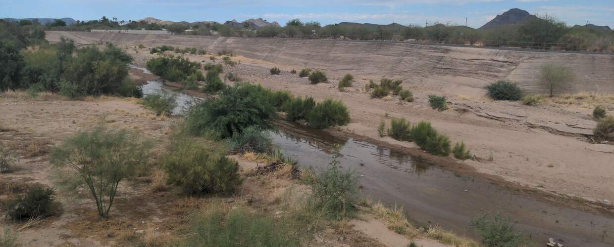
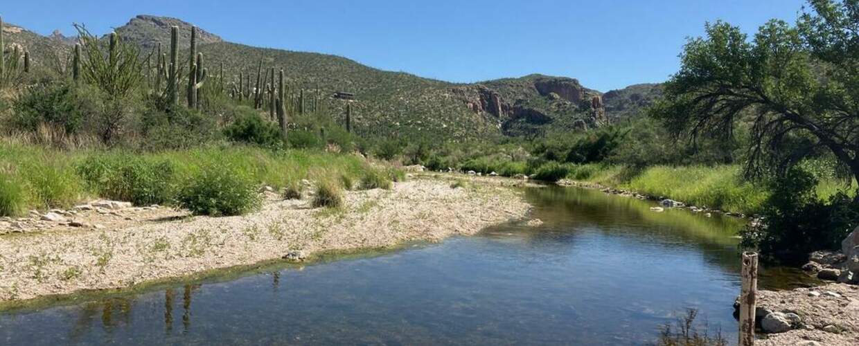
Sabino Creek & Bear Creek
Our monitors observe several sites at the base of the Catalina Mountains. On the east side of Tucson, our monitors capture data from Bear Creek and Lower Sabino Creek. These creeks start in the mountains, with rain and snowmelt feeding surface flows. When the creeks move into the valley, there are some places with shallow groundwater aquifers that support surface flow in addition to rain and snowmelt.
Flow365 Site: Sabino Creek at Wes Miller Park
Flow365 Monitors: Wendy Beall
2022 Water Year Flow: 365 Days
2016 - 2021 Water Year Flow: 365 Days
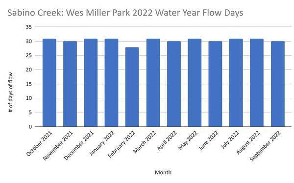
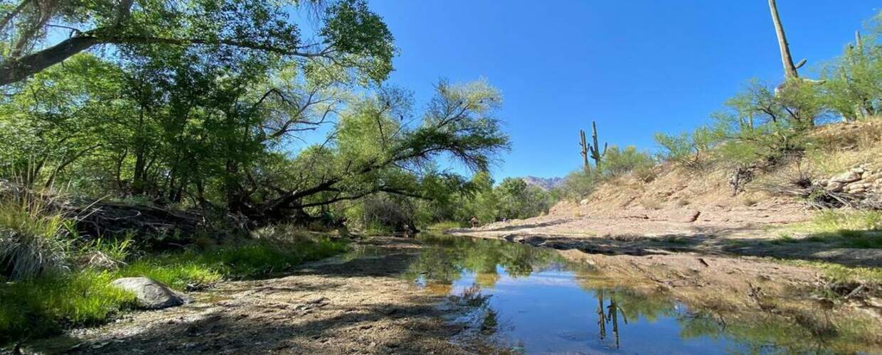
Our monitors’ data has shown that a quarter-mile of Lower Sabino Creek has been flowing nonstop since 2016. Lower Sabino Creek is privately owned by a variety of landowners, mostly residential. Used and preserved by the community around it, we have captured data since the start of our program with permissions from the surrounding private landowners and the homeowners association. The restored perennial flow is likely the result of a reduction in groundwater pumping—which over the past decade has ceased or reduced at several major pumping sites including a nearby horse ranch owned by the University of Arizona. This area is monitored by Wendy Beall, who has been a monitor in the program since 2020. She has caught some incredible wildlife along this site; most recently, we learned that this area is great for our bat population in Tucson! Bats who live in the canyons close by will use this area for drinking and eating, catching everything from mosquitos to fruit that can be found in the riparian environment.
We’ve also documented the presence of rheocrene springs in this location, springs that are found within a creek or river. The spring ensures the creek continues to flow even with upstream surface flow dries up.
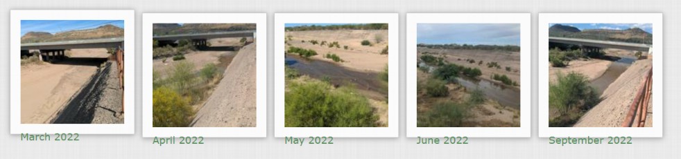
Monthly Photos at Sabino Creek Wes Miller Park:
Flow365 Site: Bear Creek at Bear Canyon Trail
Flow365 Monitors: Wendy Beall
2022 Water Year Flow: 90
Most Consecutive Flow Days: 10 days
2021 Water Year Flow: 160
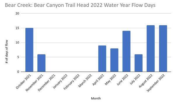
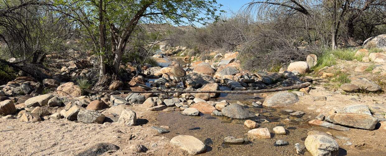
Bear Creek is a tributary to Lower Sabino Creek, located near the Sabino Canyon Recreation Area. The Bear Canyon Trail leads eventually to Seven Falls cascades and pools, a very popular hike for many Tucsonans. You can see from the data collected at this site that this part of Bear Creek does not flow year round, much of the flow is in response to rainfall and snow melt, making this an intermittent stream (seasonal flows).
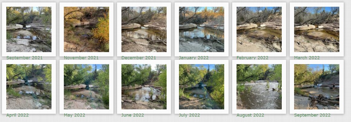
Monthly Photos at Bear Creek Bear Canyon Trail:
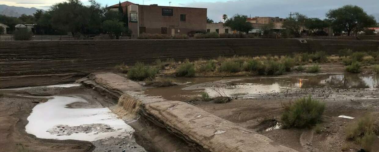
Rillito River
Because of The Loop path and many parks along its banks, the Rillito River is popular with the Tucson community as a green corridor to walk, run, bike, and picnic. The Rillito River is fed by the Tanque Verde and Pantano Creeks, flowing from east to west, eventually connecting with the Santa Cruz River. The Rillito River is also known for a large bat population, the Mexican free-tailed bats, that live in large colonies under several bridges that cross the river.
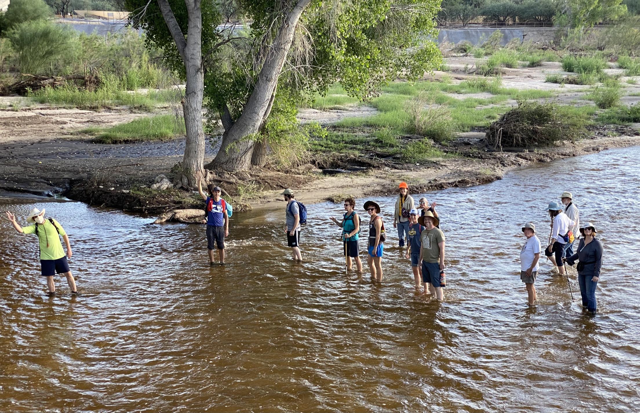
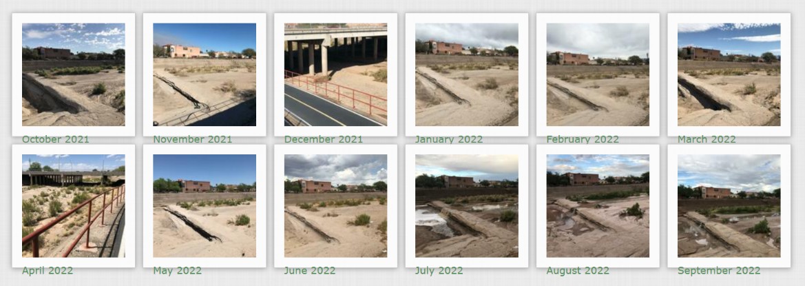
Flow365 Site: Rillito River at Craycroft Road
Flow365 Monitors: Catlow Shipek, Mike Campbell, Kerry Murphy, Susan Swartz, Oliver Wilson
2022 Water Year Flow: 62 Days
Most Consecutive Flow Days (2022): 27 days
Most Consecutive Flow Days (2021): 56 days
2021 Water Year Flow: 83 Days
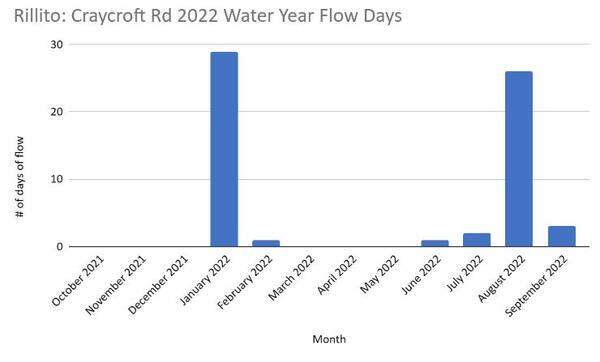
This site is the confluence of the Tanque Verde Creek and Pantano Creek and is considered a shallow groundwater area (water within 50 feet of the surface) that still supports some cottonwood trees. Historically this area had year-round flow through a large ciénega (marsh) with a large mesquite bosque (forest), supporting indigenous populations. Compared to the 2021 Water Year, there was a decrease in flow days in the 2022 Water Year, correlating with a decrease in rain. However, we still saw a significant amount of consecutive flow days, almost one month of consistent flow at this site, even with less rain.
Historically, this marsh with abundant water was the site of up to 29 diversion ditches for agriculture, one of the best known being Corbitt Ditch. Ditches, including subsurface diversions, drew water from the river to agricultural fields along the Rillito River.
The presence of cottonwood trees in this area indicates perched aquifers and/or the presence of springs, considering the groundwater is around 40-60 feet to surface level. Cottonwoods require groundwater within 25 feet of the surface. A rheocrene spring has been documented just upstream of the confluence, in the Tanque Verde Creek.
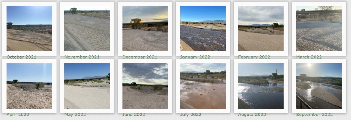
Monthly Photos at Rillito River Craycroft Road:
Tanque Verde Creek
Historically, stretches of the Tanque Verde Creek were often flowing, either seasonally or year-round. But since the mid-1900s, this creek has been drying up, with the loss of seasonal and year-round flows due to depleted groundwater levels. This area has one of the few remaining riparian forests with floodplain connection in the Tucson basin, with Fremont cottonwoods, Goodings willow, Mexican Elderberry, and Velvet mesquites, as well as many other riparian plants native to the Sonoran Desert. Unfortunately, it has more recently become home to an invasive species called Arundo donax, a giant cane reed. This highly flammable weed crowds out native plants, and sucks up 3-4 times the amount of water as native plants, diminishing flow. Through WMG’s River Run Network, we are working to remove this species along the Tanque Verde Creek and eradicate it in the next five years. Learn more about our efforts and how to get involved here.
Flow365 Site: Tanque Verde Creek at Wentworth Bosque
Flow365 Monitors: Sara Birtalan, Richard Pello, Lee Pello, Heidi Shewel
2022 Water Year Flow: 276 Days
2021 Water Year Flow: 70 Days
Most consecutive flow days: 288 days, July 23, 2021 – May 6th 2022
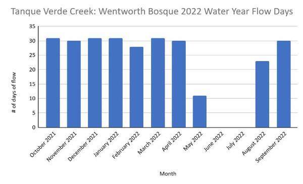
This middle stretch of the Tanque Verde Creek tells an amazing story of resilience and the potential for human’s impact on restoring flow and shallow groundwater areas. This is an area that likely had perennial flow historically, but it dried up with overpumping. The nearby golf course that was pumping groundwater switched to reclaimed water in 2005, and since then the aquifer has been steadily recovering, with seasonal flows emerging. This groundwater recovery has occurred in a time of multi-decadal drought, with many years of less than average rainfall.
WMG has observed seasonal flows in this area since 2019. Between the 2021 and 2022 Water Years, our monitors recorded 288 days of consecutive flow (July 23, 2021 - May 6th 2022) in the area, by far the most flow we’ve observed in this area. Though there was a short pause over the summer this water year, with the monsoon rains the flow picked back up again.
Despite less than average monsoon rains, the creek flowed for several months following the end of monsoon rains, showing this shallow groundwater area recharges quickly. This area has substantial opportunity to continue to see flow days and flow extent increase over time, even with potentially drier years due to climate change. More local groundwater recharge efforts, reduced groundwater pumping, and the removal of Arundo donax can continue to enhance flow in this area.
Monthly Photos at Tanque Verde Creek Wentworth Bosque:
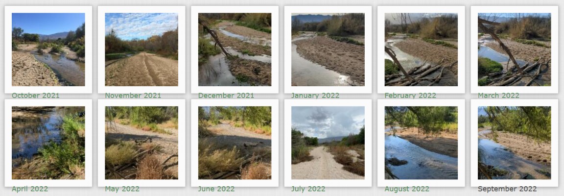
Agua Caliente Creek
North of Tanque Verde Creek, at the foot of the Catalina Mountains, Agua Caliente Creek runs just west of Agua Caliente Park and eventually meets up with Tanque Verde Creek. Our monitors have revealed that flow in this area is dependent on rain and snowmelt. Though it does not flow year round, data shows short intermittent flows throughout our winter season due to snowmelt. The creek is able to meander freely in much of its floodplain, and has more natural flow unlike some of the channelized rivers in the urban core.
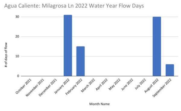
Flow365 Site: Agua Caliente Creek at Milagrosa Lane
Flow365 Monitors: Bethany DeRango, Andrea Martin
2022 Water Year Flow: 82 Days
Most consecutive flow days: 46 Days
This site is the most upstream site we have in the Agua Caliente Creek. Flow to this site starts in the Agua Caliente Canyon, and flows down through residential areas and natural floodplain, one not lined by concrete for most of the creek area, and eventually reaches its confluence with the Tanque Verde Creek. As our monitors have been gathering consistent data for this site, we have seen an interesting pattern emerge. After rain events, the flow will stay for days after the rain has stopped. We hope to learn more over time as our two monitors keep getting out and collecting data, but we are hoping to see this area continue to flourish and flow even after the rains have stopped!
Monthly Photos at Agua Caliente Creek Milagrosa Lane:
Pantano Creek
Pantano Creek originates at the confluence of Ciénega Creek and Agua Verde Creek, south of Tucson near Vail. Flow is primarily contributed from Ciénega Creek and secondarily through Rincon Creek, which originates east of Tucson near Rincon Peak. Pantano Creek flows north to join with Tanque Verde Creek at Craycroft Rd, becoming the Rillito River. Although it is fed from two creeks with seasonal and perennial flow stretches, this creek rarely flows, as the water typically sinks into the ground before it can flow over the surface into Tucson. Though there is not much flow observed from this creek, and it is disconnected from its floodplain due to concrete bank stabilization, the creek has a beautiful meandering pattern when it does flow, emulating the natural course a desert river takes.
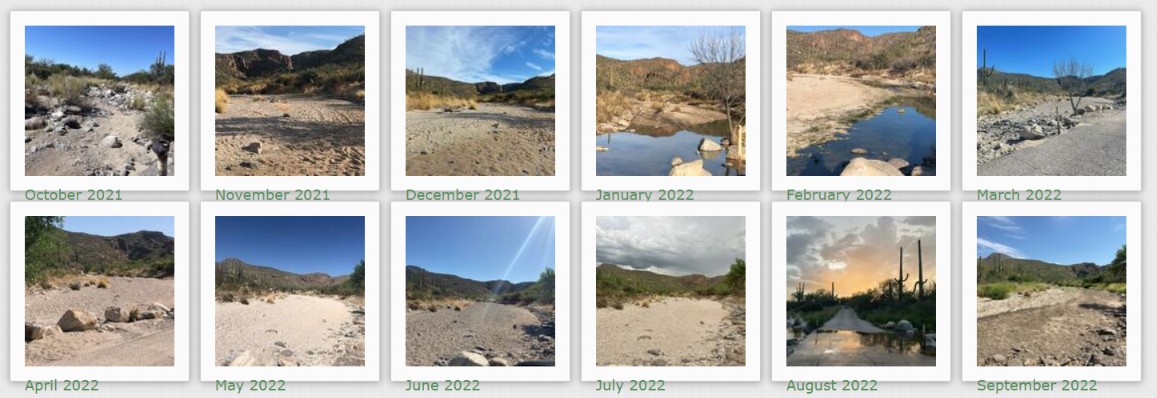
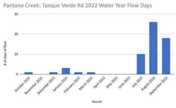
Flow365 Site: Pantano Creek at Tanque Verde Road
Flow365 Monitors: Greg Mishaga, Susan Syracuse, Carol Bauer
2022 Water Year Flows: 61 Days
Most consecutive flow days: 14 Days
The area surrounding this site is highly urban. You can see in the photos from monitors the buildings on either side of the creek. There are people and cars that pass over this bridge on a daily basis, making it a very interesting and lively site for the Flow365 monitors. This is also the last site we have along the Pantano before it merges with the Tanque Verde Creek. With this in mind, we can understand more of where the water that flows along the Rillito is coming from. Much of it comes from the Tanque Verde while there is rain and snowmelt from the Catalina and Rincon Mountains, but with many storms and flow coming from the Cienega Creek area and Rincon Mountains, the Pantano supported quite a bit of the flow as well.
Monthly Photos at Pantano Creek Tanque Verde Road:
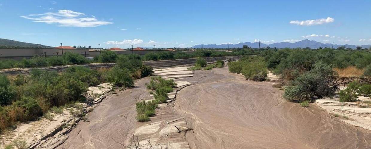
Cañada del Oro River
The Cañada del Oro River originates in a remote portion of the Catalina Mountains north of Tucson. Fed by rainfall and melted snow, it flows north toward the town of Oracle and then turns south toward Oro Valley, where it is usually seen as a dry riverbed. The Cañada del Oro ultimately feeds into the Santa Cruz River just northwest of the city.
Historically, the Cañada del Oro River was largely intermittent and ephemeral, this means that even without groundwater pumping and floodplain channelization, it only had above ground flow during rainy seasons. However, there are reports that some areas were plentiful with water close to the surface, like at the Steam Pump Ranch in Oro Valley. This means that even though there was no surface flow, much of the Cañada del Oro River could have been considered a shallow groundwater area.
Flow365 Site: Cañada del Oro River at 1st Avenue
Flow365 Monitors: Angela Greynolds, Kelly Windsor, Johanna Stansfield
2022 Water Year Flows: 16 Days
2021 Water Year Flows: 12 Days
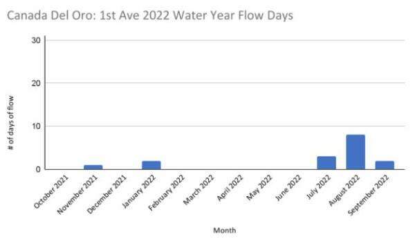
This site is one of the upper Cañada del Oro sites we have in the program. It is also one of the most consistently monitored in the area with 3 monitors visiting almost every week. We consider this area ephemeral, only flowing when there is rainfall, and even with rain, it does not flow often. Historically, this area would have been considered intermittent, flowing for a short time after the rains subsided, but not flowing year round. The Cañada del Oro River, unlike many of our concrete-lined rivers in Tucson, is able to reach its natural floodplain in some areas, slowing the water down and sinking it into the ground sooner than it is able to flow above ground to the other sites we have in Flow365.
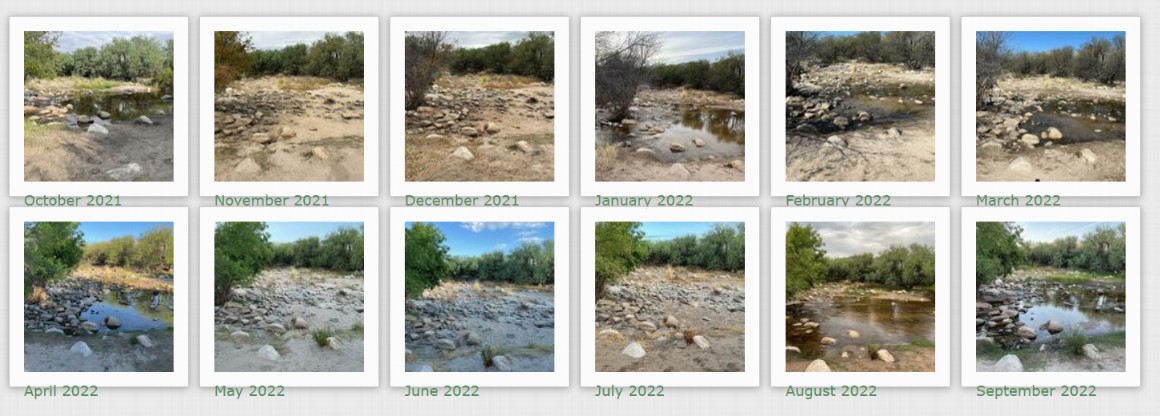
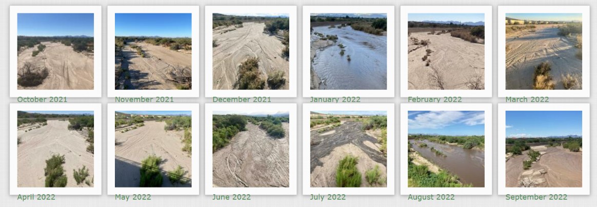
Monthly Photos at Cañada del Oro River 1st Avenue:
Thank you for reading our Flow365 Annual Report, we look forward to gathering more data and presenting reports in the years to come.
References:
1. Sonoran Institute. “Living River Charting Santa Cruz River Conditions.” September 19,2022, https://sonoraninstitute.org/files/Living-River-Downtown-Tucson-to-Maran...
2. unknown. “Superfund Site: Tucson Airport Remediation Project: Page 2 of 2.” ADEQ Arizona Department of Environmental Quality, 3 Feb. 2023, https://azdeq.gov/superfund/tucson-airport-remediation-project?page=0%2C...