
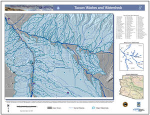
Do you know your local watershed? This large-format map shows the washes (usually dry rivers) that run throughout the Tucson basin, and their associated subwatersheds. The map also shows riparian habitat categorized under Pima County's Sonoran Desert Conservation Plan, and provides basic information about the significance of washes and watersheds to our human and natural community.
Map produced by TerraSystems Southwest for Watershed Management Group, using data from Pima County and the City of Tucson.